Driving Directions & Trail Heads
GPS: 36-24-42N x 092-21-59W
West side trail head
(200 series trails) | East
side trail head (100 series trails)
Want to check the weather before you
come? Click for local weather forecast
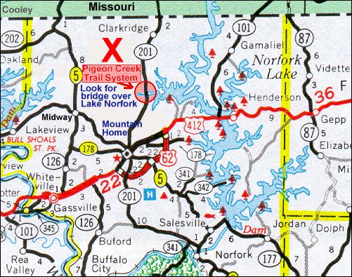
The Pigeon Creek National
Recreation Trail is located in Pigeon Creek Park, a Corps of Engineers 'Day-Use' area on
Lake Norfork. This trail system is open to bicycle and hiking use only.
From Mountain Home, take Hwy 201 North approx 5 miles. Just across the Pigeon Creek Bridge, a
small parking area and trail head are on the left (west). This is the trailhead for the
'200' series, and the 'Lost Mine Trail' that connects to the Wolfley Hole system. Less
than 100 yards further north on Hwy 201, is the entrance to Pigeon Creek Park on the right
(east). Here you will find the trailhead for the '100' series. A picnic table and kiosk
with map are on the left, just inside the park.
From Missouri, take Hwy J south from its intersection with Hwy 160 near Hardenville (
just East of Gainesville). Hwy J becomes Hwy 201 at the State line. Approximately 6 miles
from State line, look for Pigeon Creek Park on the left. If you cross the Pigeon
Creek Bridge, then you've gone too far.
click for printable
version of map & directions
page top
|